[broadstreet zone=”59946″]
NORTON – The National Weather Service out of Boston/Norton has issued a Tropical Storm Warning for southern New England, to go along with a flash flood alert.
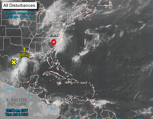
Tropica Storm Elsa is over the Carolinas today, July 7.
The storm intensity is 45 mph.
Tropical Storm Elsa is forecast to track near Block Island and the south coast Friday. The strongest winds should arrive Friday morning and be focused along the coastal waters and near the shoreline, especially on Cape Cod and the Islands. The threat for flooding rain should be greatest across interior southern New England and northeast Massachusetts, where the heaviest rain is expected to fall.
Elsa will rapidly exit the region by Friday night.
[broadstreet zone=”59945″]
Prepare for life-threatening rainfall flooding having possible extensive impacts across.
Potential impacts include: Major rainfall flooding may prompt many evacuations and rescues, especially in urban areas.
Rivers and tributaries may rapidly overflow their banks in multiple places. Small streams, creeks, and ditches may become dangerous rivers.
Streets and parking lots become rivers of moving water with underpasses submerged – Think Route 9 at Route 126 in Framingham.
Driving conditions become dangerous. Many road and bridge closures with some weakened or washed out.
Prepare for dangerous wind having possible significant impacts near the South Coast, Cape Cod, and the Islands.
[broadstreet zone=”59948″]
Some damage to roofing and siding materials, along with damage to porches, awnings, carports, and sheds. A few buildings may experience window, door, and garage door failures. Mobile homes damage is possible, especially if unanchored. Unsecured lightweight objects could become dangerous projectiles.
Several large trees could snap or become uprooted, causing power outages.
Some roads may become impassable from large debris, and more within urban or heavily wooded places. A few bridges, causeways, and access routes could become impassable.
Scattered power and communications outages, are possible.
Resident should prepare for a tornado event having possible limited impacts across Southern New England.
[broadstreet zone=”59982″]
Now is the time to check your emergency plan and emergency supplies kit and take necessary actions to protect your family and secure your home or business. If you live in a place particularly vulnerable to flooding, such as a low-lying or poor drainage area, in a valley, or near a river, plan to move to safe shelter on higher ground. When securing your property, outside preparations should be concluded as soon as possible before conditions deteriorate.
The onset of strong gusty winds or flooding can cause certain preparedness activities to become unsafe. If you are a visitor, know the name of the county in which you are located and where it is relative to current watches and warnings.
Weather Service will issue its next alert around 6 p.m. today, July 8.
[broadstreet zone=”59983″]

