
[broadstreet zone=”52093″]
FRAMINGHAM – Definitive Healthcare, a provider of data, intelligence, and analytics on the healthcare provider market, today, March 18, announced it has partnered with Esri, the world’s largest location intelligence company, to help deliver data through an interactive mapped data service to enable analysis, visualization and tracking of US hospital bed capacity, and potential areas of geographic risk, during the COVID-19 outbreak.
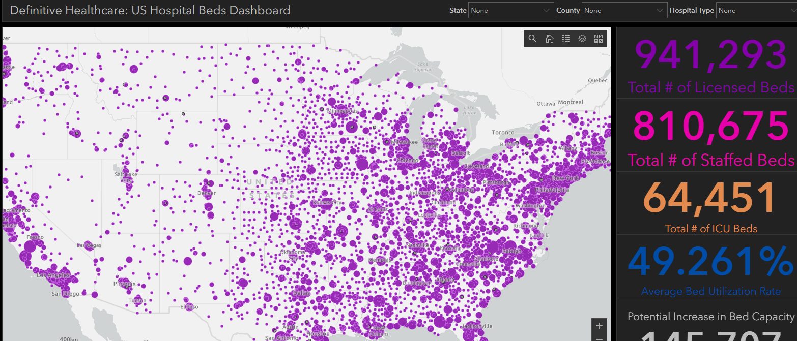
These resources illustrate the location and number of licensed beds, staffed beds, ICU beds, and total bed utilization rates in hospitals across the United States.
[broadstreet zone=”53820″]
The Esri COVID-19 GIS Hub also contains other data layers such as an overlay of US Census data to help decision-makers compare the surrounding US population with the total number of available hospital beds.
These resources were developed to provide researchers, public health authorities, and the general public with user-friendly information to help identify geographic areas of risk – with a low capacity to accommodate sick patients – as COVID-19 unfolds.
In this dashboard, Definitive Healthcare’s data and intelligence is spatially enabled by Esri’s Geospatial Cloud – depicting the most accurate view of where in the US, and at which hospitals, additional bed capacity could be accommodated.

“As the COVID-19 virus spreads in the U.S., and around the world, public health providers and other types of responders have been trying to understand which areas may require the greatest amount of aid. We built this geographic map of US hospital bed utilization and capacity to solve some of these challenges,” said Este Geraghty, ESRI’s Chief Medical Officer. “We have been using Definitive Healthcare’s industry-leading healthcare datasets for several years and have relied on their platform’s accuracy and depth for many of our research endeavors. In times such as these, accessible and actionable information is crucial, and we know we can count on our long-standing relationship with Definitive Healthcare during this time of worldwide need. This partnership is truly a match made in heaven.”
Access Esri’s COVID-19 GIS Hub to review and use relevant information from across the globe. Alongside Definitive Healthcare’s US Hospital Bed Data the hub contains several useful maps and tools for tracking information about the spread and mitigation of coronavirus disease around the world. In addition to the Definitive Healthcare-powered map, other tools include a deeply informative
[broadstreet zone=”58610″]
“Coronavirus COVID-19 Global Cases” dashboard, created by the Center for Systems Science and Engineering at Johns Hopkins University, GIS apps that illustrate data at the regional level in China, Italy, Japan, and Hong Kong, and a story map article that examines age and social vulnerability in the context of Coronavirus.
“We are happy to support our long-time client, ESRI, with essential data to help them provide powerful intelligence on healthcare providers to governments that are recommending actions to manage the impact of COVID-19 worldwide,” said Jason Krantz, Founder and CEO of Definitive Healthcare.
“We support their mission fully and want to do our part to share pertinent, relevant, and actionable information to people who need to make important decisions for their countries, communities, and families. This is an unprecedented time, and we are committed to doing everything we can by providing the data necessary to help manage this crisis,; said Krantz.