By Jack Landsiedel
***
[broadstreet zone=”58610″]
NATICK – The Charles River Dam Advisory Committee is set to make a decision to repair or remove the Charles River Dam in South Natick during its July 26 meeting.
Over the past year and a half, the committee has considered community feedback, impact analyses, and industry plans for both options.
The Natick Select Board will pick up the issue next month.
The Town of Natick owns the dam, located near the intersection of Route 16 and Pleasant Street, and is currently liable for potential damages caused by it.
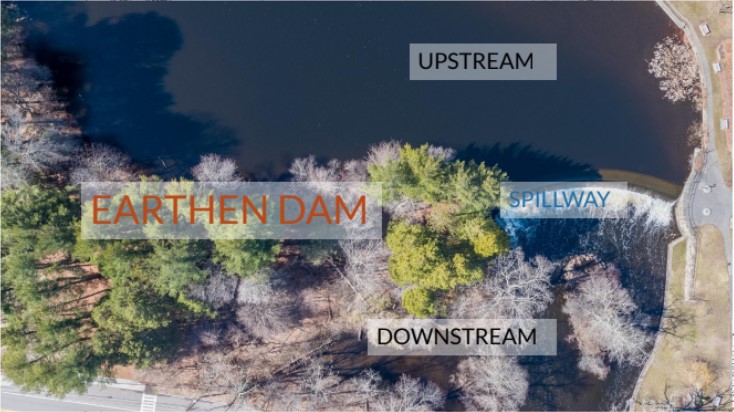
The MassDCR Office of Dam Safety (ODS) has recently changed the dam’s condition rating from fair to poor, citing “significant structural, operation and maintenance deficiencies” between the earthen dam and river spillway. 148 properties with a total estimated value of $576 million stand in the flood zone.
[broadstreet zone=”59982″]

Source: Town of Natick Public Advisory Session Slideshow (May 17, 2021)

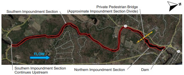
Source: Stantec, Charles River Dam Advisory Committee Slideshow (June 27, 2022)
The Committee has been working with engineering firm Stantec to design the dam’s removal. Stantec has conducted 60 dam removal assessments and eight removals under contract with the Massachusetts Division of Ecological Restoration (DER). They provided their final report on June 27.
In a removal scenario, river depth will drop 3-5’ in the northern impoundment section and about 1’ in the southern impoundment section (see map above), leaving depths ranging 1-2’. A ¼ mile section just upstream of the dam will be left with 6”-1’ of water.
Additionally, the northern impoundment section will see a 20-25% reduction in width and just a 5% reduction in the southern impoundment section. Neither depth or width are expected to change downstream of the dam.
The pond-like area in the northern impoundment section will merge into the abutting vegetated wetlands once the river flow is redirected. Throughout, “paddling conditions anticipated to be similar to flow through existing Pleasant Street Bridge and in reach downstream of dam” according to Stantec, but river depth should be considered. There is also “some uncertainty related to potential for historic rapids at or near spillway.”
[broadstreet zone=”59983″]
New probable costs have been released this year based on professional assessments, park improvements not included. An itemized budget can be found in the Committee’s June 27 meeting slideshow. While both projects will rely on local taxes for funding, multiple state and federal grant options have been identified.
Removing the dam is a one-time cost of $1,511,000 entailing a dewatering impoundment and spillway removal. No operational or maintenance costs are foreseen as removal will eliminate the dam structure, meaning that the town will no longer be liable for potential property damage and inspections will not be required as the river will now flow freely. The option involves a 1.5 year engineering and permitting phase and 1.5 year construction phase.
The total cost of repair is $3,090,000 and is estimated to take three years, with 2.25 years devoted to engineering and permitting and 0.75 to construction.
One-time costs of fixing the earthen berm and entrainment wall as well as replacing the fishing ladder are estimated at $2,260,000.
The repair option will require $830,000 in operation and maintenance costs over the first thirty years including general dam maintenance, annual fish ladder maintenance, DCR biennial compliance, and preventative maintenance every 15 years.
[broadstreet zone=”59947″]
Repairing the dam also means that approximately 60 mature trees and undergrowth on the earthen berm will be removed. Measures mitigating erosion control including embankment regrading, a stone rip rap, and spillway training walls will also be installed.
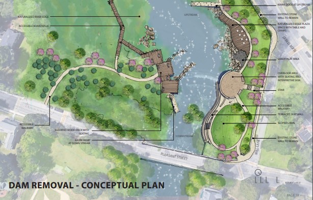
Iris Lin, Senior Landscape Architect at Halvorson, presented conceptual plans for converting the dam area into an accessible park. In either a removal or repair decision, the area can be converted into a usable open space for sitting, boating, and fishing on both sides of the river.
The maps below show how a potential park would be implemented and how the river shoreline is expected to change in the removal option.

Source: Halvorson, Charles River Dam Advisory Committee Slideshow (June 14, 2022)

Source: Halvorson, Charles River Dam Advisory Committee Slideshow (June 14, 2022)
The Charles River Watershed Association published a report in March called “A River Interrupted: Why Dam Removal is Critical for Restoring the Charles River.” They believe “we have the opportunity of a lifetime to remove aging, derelict dams, and restore a natural, free-flowing Charles River.”
There are currently 19 dams on the river’s 80-mile journey from Hopkinton to Boston.
“Today the river suffers impaired water quality, loss of habitat, impeded fish passage, invasive species growth, contaminated sediment, and harmful cyanobacteria blooms,” the group said.
[broadstreet zone=”53130″]
Dams themselves harm the riverbed. Water upstream of dams face higher temperatures, evaporation, accumulation of sediments and nutrients, and low-oxygen levels. Here, invasive species have adapted to thrive while native plant and animal species are removed from their habitat. Downstream, fast-rushing water erodes the river bottom “creating a lifeless, empty streambed” lacking natural biodiversity.
The rigid shoreline adapted around dams are not flexible to the impacts of climate change. Precipitation during heavy rain events has increased 70% in the Northeast since 1950. Increased flooding and water flow heighten the risk for maintenance, repair, and dam failure compared to when the dams were first installed.
Emily Norton, Executive Director of the Charles River Watershed Association (CRWA) told Source that “The fish and animals and plants that need the river for survival evolved over thousands of years without a dam there. Having the dam in place is inarguably worse for the health of the river and the flora and fauna that rely on the river and have inhabited the river for thousands of years,” resulting in numerous harmful ecological effects on the river ecosystem.
[broadstreet zone=”58892″]
“I think it is very important for residents to keep in mind that the aesthetics are going to change, regardless of whether the dam is removed. If the dam is removed, it will be a beautiful, free flowing river. If the dam is repaired, the sixty mature trees on the earthen embankment will be removed, making for a very different, bare landscape without the beauty or cooling effects of those trees.
Efforts to establish a free-flowing waterway are echoed by the Natick Nipmuc Indian Council, the tribe native to the area which have historically relied on the untouched lakes, streams, and rivers. Kristen Wyman, member of the Council and the Charles River Dam Advisory Committee continues to advocate for indigenous perspectives and supports the removal of the dam to honor the culture, history, and ecology of the river.
Those opposed to dam removal are concerned that the river will lose its beauty for residents using the area for walking, picnicking, boating, and fishing. “The dam has stood for nearly a century and has become an iconic backdrop to historic South Natick,” Save Natick Dam organizers said.
Their petition has over 900 signatures as of July 13.
[broadstreet zone=”58893″]
The most recent information provided by the Town shows that removal will cause water depth for a ¼ mile section north of the dam to drop to 6-12”, but “for many months of the year, it will be lower than this, and river travel with a canoe or kayak will be difficult or impossible.”
Urging the Committee to repair the dam, organizers predict “there will no longer be the sound of the water running over the spillway, nor the mist that forms as a result, nor a large beautiful pond.”
Jillian Wilson-Martin, Director of Sustainability with the Town of Natick and member on the Charles River Dam Advisory Committee provided the following statement to SOURCE: “It’s a big decision, but the Charles River Dam Advisory Committee has done its homework. Over the past year, members took field trips to dam repair and river restoration sites, received presentations from a variety of experts, and sought to engage the community at each step of the journey. The Committee’s recommendation will be an informed one, and I am grateful to Committee members for giving so much of their time and attention to this important issue. I encourage residents to visit natickma.gov/crdam to review the Committee’s research on both options.
After hearing public comment, the Committee will deliberate during their second to last meeting on Tuesday, July 19 from 4 to 7 p.m.
Residents and stakeholders are invited to join using this Zoom link.
On July 15, the Committee published this FAQ document answering common questions about the proposed projects.
For more information about the Committee, including past and future meeting agendas, presentations, recordings, and summaries, please visit their website.

***
Jack Landsiedel is a Framingham resident and graduate of Stapleton Elementary School, Christa McAuliffe Charter School, and Framingham High School (Class of 2020). He is a rising senior at the University of Maryland, College Park where he is majoring in Government & Politics with a minor in International Development & Conflict Management. He is looking forward to studying abroad at Queen Mary University of London this fall and exploring nearby countries. In the future, he hopes to pursue a career in Washington D.C. involving policy, leadership, and sustainability. This summer, he is a SOURCE intern covering government & politics.
[broadstreet zone=”59982″]

